Due to the ongoing wildfires in California, the air quality in parts of the North Bay and East Bay regions of the San Francisco Bay Area are "deteriorating significantly," according to air quality officials, The San Francisco Chronicle reported.
"Unfortunately, there's a lot of smoke," a spokesperson for the Bay Area Air Quality Management District (BAAQMD), Kristine Roselius, told The Chronicle. "The wind has shifted and the smoke from the Glass Fire is moving southeast into those areas like Napa, St. Helena and down into the East Bay."
A health alert has been issued by Spare The Air, the alert system of the BAAQMD, with the air quality expected to remain "unhealthy" through Friday in the Bay Area's Northern Zone and Eastern Zone.
A Spare The Air alert is issued "when fine particle pollution is expected to build up to unhealthy levels," the system's website stated.
Over 17,000 firefighters are battling 26 major wildfires in California, while crews also responded to 26 new wildfires on Wednesday, according to the latest report Wednesday by the California Department of Forestry and Fire Protection (Cal Fire).
A Fire Weather Watch has been in effect from Wednesday evening in Monterey County and the North Bay, which may potentially affect the Glass Fire, Cal Fire noted.
Today, 9/30, and tomorrow, 10/1, Spare the Air Alert! Bay Area air quality is expected to be Unhealthy in the Northern Zone and the Eastern Zone, Unhealthy for Sensitive Groups in all other regions. pic.twitter.com/CqQ4BjJAzA
— Bay Area Air Quality (@AirDistrict) September 30, 2020
"Locally gusty winds could be experienced in the Sierra and associated foothills, and southern California mountain regions. A cooling trend is expected to arrive over the weekend, lowering temperatures and raising humidity," Cal Fire said.
🔥BLM Wildland Fire map for Sept. 30. This is a map of all active large fires within California and the BLM-managed acreage affected. For the latest fire info: https://t.co/p10omwOfww #FireYear2020 #CAWildfires #BePrepared pic.twitter.com/LCus4C3yF7
— Bureau of Land Management California (@BLMca) September 30, 2020
Here are updates on some of the latest major fires across the state.
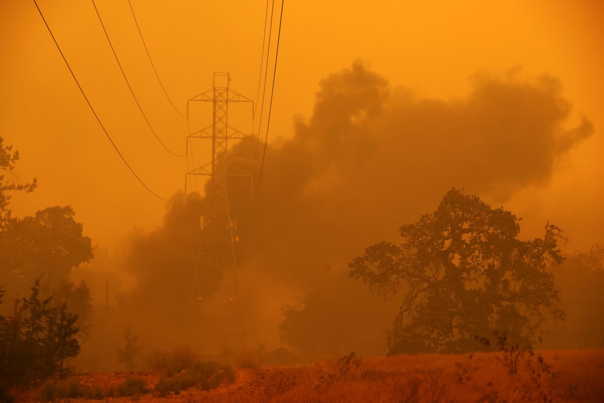
Glass Fire
- Location: Napa and Sonoma counties.
- Acres: 51,266.
- Containment: 2 percent.
- Structures threatened: 26,290.
The Glass Fire continued to burn actively throughout Wednesday. "Extremely dry fuels combined with warmer and drier weather has allowed short range spotting. Hot and dry weather is anticipated over the next several days," Cal Fire noted in its latest report Wednesday.
🔥🚒For the latest on where the evacuation orders are impacting the #GlassFire burn area, check out this link via @CountyofNapa https://t.co/uG6K7zeK5s pic.twitter.com/GjexqIE2np
— Cal OES (@Cal_OES) September 30, 2020
A Red Flag Warning has been issued for the North Bay Mountains and areas at and around theGlass Fire from 1 p.m. local time Thursday, the National Weather Service (NWS) confirmed.
"While not expecting the same critical fire conditions as what was observed earlier this week, critically dry and breezy conditions are expected in the area," the NWS Bay Area noted in a post Wednesday on its official Twitter account.
Additional evacuation orders and warnings were issued for several parts of Napa County. See Cal Fire's full report for details.
Please 👇click this link👇 to see today's Perimeter Map of the #GlassFire https://t.co/6Wc0dVGWzJ pic.twitter.com/gmjkUO7eWj
— CAL FIRE LNU (@CALFIRELNU) September 30, 2020
Zogg Fire
- Location: Shasta County.
- Acres: 55,046.
- Containment: 9 percent.
- Fatalities: 4.
- Structures threatened: 1,538
The Zogg Fire continued to burn in grass, oak woodland, chaparral and mixed timber on Wednesday. Hot and dry weather conditions were forecasted for Wednesday evening with a north westwind building over the area, according to Cal Fire's latest report Wednesday.
Evacuation orders and warnings remain in place across multiple parts of Shasta and Tehama counties. See Cal Fire's full report for details.
#ZoggFire Map 9.30.20 @ShastaSheriff @211Norcal pic.twitter.com/wRrxGkUcna
— CAL FIRE SHU (@CALFIRESHU) September 30, 2020
August Complex Fire
- Location: Mendocino, Humboldt, Del Norte, Trinity, Lake counties.
- Acres: 949,672.
- Containment: 47 percent.
- Fatalities: 1.
The August Complex Fire is split across the North, South and West zones.
The fire in the South Zone has burned at least 489,151 acres, with 70 percent contained, while the blaze in the North Zone has burned at least 341,488 acres, with 37 percent contained. The West Zone of the fire has grown to 118,876 acres, with 65 percent contained, according to Cal Fire's latest report Wednesday.
Active fire behavior was seen in the North Zone, with single and group tree torching along with uphill runs, according to the latest report Wednesday from the Incident Information System of the National Wildfire Coordination Group (NWCG).
"Fire established north of Highway 36 is becoming problematic with limited road access and steep terrain. The fire will continue to spread in the 1987 Plume fire where fuels are conducive to rapid fire spread.
"In the south zone, interior fuels continue to smolder throughout the fire area. Fire behavior has been minimal," but "moderate potential for growth remains a concern," the NWCG report said.
An evacuation warning is in place in Humboldt County for areas east of Bell Springs Road to the Trinity County line and south of Pipe Creek to Mendocino County line.
Evacuation orders, warnings and road closures remain in effect across multiple parts of Trinity, Mendocino and Lake counties. See Cal Fire's full report for details.
August Complex South Zone Fire Update & Map for September 30@ShastaTrinityNF @SixRiversNF@CALFIRE_MEU#AugustComplexSouthZone#AugustComplex pic.twitter.com/obvHjujjOh
— Mendocino NF (@MendocinoNF) September 30, 2020
Creek Fire
- Location: Fresno and Madera counties.
- Acres: 307,051.
- Containment: 44 percent.
- Structures threatened: 4,576.
The North Zone of the Creek Fire saw a slight progression northeast near Cattle Mountain on Wednesday. Fire activity is expected in Chetwood Creek, Norris Lake, East Fore Chiquito, and northeast of Little Shuteye Peak and south of Whisky Falls, Cal Fire confirmed in its latest report Wednesday.
A "slow, steady, active fire spread in the downwind direction," is expected in the South Zone of the fire.
"Deep seated fire in heavy fuels will advance through high intensity surface fire. As the expanding fire front transitions from backing to head fire through slope reversal, very steep terrain will support short, aggressive runs through tightly spaced timber," the NWCG noted in its latest report Wednesday.
Evacuation orders, warnings and road closures are in place across parts of Fresno and Madera counties. See Cal Fire's full report for details.
#CreekFire Incident Map Update 09/30/20 pic.twitter.com/LEaU1vck5r
— CALFIRE/FresnoCoFire (@FresnoCoFire) September 30, 2020
Bobcat Fire
- Location: Los Angeles County.
- Acres: 114,438.
- Containment: 63 percent.
- Structures threatened: 6,000.
Minimal fire growth, mostly due to the interior island near Mount Wilson (Division A) continuing to burn, is projected for the Bobcat Fire, according to the latest report Wednesday by the NWCG.
Mop-up work continues northwest of Mount Wilson from Mount Wilson Red Box Road to Highway 2 and near Mount Waterman.
The southern end of the blaze remains moderated, with patrol and mop-up work taking place from Mount Wilson to the Crystal Lake area.
The closure of seven National Forests (NF) has been extended a week through October 8. The closed forests include Angeles NF, Cleveland NF, Los Padres NF, Inyo NF, San Bernardino NF, Sequoia NF and Sierra NF.
Evacuation orders, warnings and road closures remain in place across several parts of Los Angeles County. See the full NWCG report for details.
SQF Complex Fire
- Location: Tulare County.
- Acres: 152,169.
- Containment: 58 percent.
The SQF Complex Fire includes the Castle and Shotgun fires.
In the East Zone of the Castle Fire, "Almost all threats from fire have been abated. Threats from secondary fire effects such as hazard trees and soil erosion remain across the entire fire," as of Thursday, the NWCG confirmed in its latest report.
Minimal fire growth is expected in the West Zone of the Castle Fire, while the fire located within and above the thermal belt is expected to be the most active areas, the report confirmed. Minimal fire growth is expected for the Shotgun Fire.
Evacuation orders have been downgraded to warnings in the Mineral King and Silver City areas as well as the remainder of South Fork Drive and residences on Blue Ridge Drive.
Evacuation warnings have been lifted in the Three Rivers, South Fork Drive (below Conley Bridge), south of Heidi Drive, Cherokee Oaks and the Balch Park areas, including Bear Creek to Rancheria Fire Road and Balch Park Road to Blue Ridge Drive.
All other evacuation orders and warnings remain in effect. See the full NWCG report for details.
#SQFComplex, #EastCastleZone Daily Update
— Sequoia Nat'l Forest (@sequoiaforest) September 30, 2020
Size: 151,426 acres
Containment: 61 %
Total Personnel: 1,838@TulareSheriff @TulareCoFire @CountyofTulare @Inyo_NF @SequoiaKingsNPS pic.twitter.com/ZdRGn8oRjf
Red Salmon Complex Fire
- Location: Humboldt County.
- Acres: 124,464.
- Containment: 31 percent.
Fire behavior of the Red Salmon Complex Fire was moderated by the smoke with reduced temperatures over the fire. Persistent fire behavior is projected for the next 48 to 72 hours, according to the latest report Thursday from the NWCG.
"The fire will continue to move to the east, south and west, mainly through slope driven and fuel driven runs due to the very warm and extremely dry conditions. Rollout is another main contributor to fire spread," the NWCG noted.
The Forks of the Salmon area remains under an evacuation warning, while Six Rivers and Klamath National Forests are closed. See the full NWCG report for more information on evacuations and road closures.
5 of the largest wildfires in CA history have occurred this year. As we move further into fall we recognize that we still have the potential to experience more large & damaging wildfires so we remain prepared. Make sure you & your family also plan, prepare, & stay aware. pic.twitter.com/blmgo4r52p
— CAL FIRE (@CAL_FIRE) September 30, 2020
Other fires
- Slater/Devil Fires in Siskiyou County: 154,145 acres; 48 percent contained.
- North Complex Fire in Butte, Plumas, Yuba counties: 314,949 acres; 79 percent contained.
- Dolan Fire in Monterey County: 124,924 acres; 87 percent contained.
- Slink Fire in Mono County: 26,759 acres; 86 percent contained
- Blue Jay Fire in Mariposa County (Yosemite National Park Wilderness): 4,673 acres; 50 percent contained
- Rattlesnake Fire in Tulare County: 4,070 acres; 0 percent contained.
For the latest up-to-date information on these fires and others in the state, visit the Cal Fire website.
Uncommon Knowledge
Newsweek is committed to challenging conventional wisdom and finding connections in the search for common ground.
Newsweek is committed to challenging conventional wisdom and finding connections in the search for common ground.
About the writer
Soo Kim is a Newsweek reporter based in London, U.K. She covers various lifestyle stories, specializing in travel and health.
Soo ... Read more
To read how Newsweek uses AI as a newsroom tool, Click here.